Saturday, July 31, 2010

Quiet Days in Dawson

The weather has absolutely fantastic here in Dawson. Sunny and, yesterday and today, very hot (25C+) with little humidity. Fortunately, it cools down to about 10C at night which is very comfortable for sleeping. The last two days have been quiet ones for us. Spent time poking around Dawson. Had a personal tour of the inside of the RCMP station here by the Detachment Commander. Visited the Jack London museum and cabin, the Robert Service Cabin, Pierre Burton's house and several other sites in the town. Spent some time in the Parks Canada center looking at films on the gold rush era and this morning saw two good films at the Palace Grand Theatre. One was titled, "Good Time Girls" describing the women who first came to the Klondike in the early days of the gold rush. They found out that gold mining was far too strenuous for them and that they could make more money by mining the miners. The documentary groups dancers, singers and actresses, and whores as the good time girls. The difference between the three categories was really blurred but all three were well respected in the community. Many of them wound up married to very rich powerful people in the area.
The second film of the morning was a general one on the gold rush. Did you know that at one time there were over 250 stern-wheeler boats plying the rivers of the Yukon and that over 100,000 people came up here looking for gold?
The farmers market was open this morning and the produce was excellent. We bought fresh field tomatoes, beet greens, swiss chard, cucumbers, basil, parsley, zucchini and romaine lettuce. There was plenty of produce at the market, but our storage capabilities limited us to how much we could buy. Potatoes, turnip, carrots, dill, fennel, were just a few of the other options available.
This afternoon was spent at the campground getting ready to leave for Whitehorse in the morning. Also gave me time to add another 60 or so photos to BC to the Yukon Album, so be sure to check them out.

Quote of the day:

I’m not sure I want popular opinion on my side -- I've noticed those with the most opinions often have the fewest facts.
  - Bethania McKenstry

Cheers

P & N

Friday, July 30, 2010

Dawson City & The Dempster

Well, I survived the dancing girls last night, only through N's insistence that we sit as far away from the stage and front of the show area as possible. So we moved upstairs to the balcony which effectively put me 20 feet higher than the girls. In reality it was N who was scared of getting pulled up on stage.  However, I did manage to spend some time at the black jack table and actually walked away almost even for the night. I didn't play the slots because you could lose too much too quickly. I had a glass of white wine which I nursed  all evening. N fell in love with a drink called Gertie's Garter. We didn't think that the floor show was as good as the last time we were here. We left around 11:30 at night and drove up to the top of the midnight Dome to take pictures of the sunset. The sun had just slipped below the horizon but still plenty of light to take this picture of the Yukon River. Twilight probably lasts until 2 AM.
Bright sunny morning this morning (Friday). We packed up and started up the Dempster Highway to go as far as Tombstone Provincial Park. We just love it up in this part of the county. You move through the receding tree line and into arctic tundra. Beautiful mountains and a rough road. They have had a lot of rain up here and the dirt roads are showing it. The rough part we drove through in the morning was all graded and smooth by the time we drove back. Two road graders, 2 drivers, one water truck (to wet down the road before grading) and one driver graded about 30 km of road. I figure it would take at least two graders with relief drivers, five flagmen, six Dept. of Highways trucks, 7 supervisors ( to lean on the shovels) and three engineers in white hard hats to fill out all the required forms to the same job in N.S.  We also discovered that the Yukon Government is just in the process of completing a new interpretative center for the Tombstone area. They must have funded it all themselves because there was not a single Harper's save the economy (action plan) sign around. It is just a first class job. Well constructed, environmentally sustainable, photoelectric solar panels for power etc, southerly exposure and roof almost to the ground on the north side.

We only saw one moose in a lake about two km from the road down in a valley and we are about 2 weeks too early to see the tundra fall colours. We did get a close up look at the tundra and the colours are starting, just a few small leaves at a time mainly the reds and yellows. The Park staff say signs are pointing to an early fall here. Spring was early this year with beautiful weather in March and April. The fire weed is beginning to fade from reds to pinks.
We had an easy drive back to Dawson City. Had to suffer through another meal of salmon and then went downtown for our evening walk. It is like a ghost town here. Very few tourists. The Top of the World Highway opened up this morning but we have not seen a single unit come in yet. Still only five or six sites occupied here out of 98. We are here until Sunday morning when we head back down the road to Whitehorse for a few more days there. Just read on the news that the Cassiar Highway has been closed 30km south of the Yukon border due to a major forest fire. We must be the jinx for that piece of road. Three years ago when we dove the Cassiar, washouts and mudslides closed the road for a few days after we passed through. This is all for tonight. Noticed it is 2:38 AM in N.S and 10:38 in the Yukon and I'm in broad daylight.

Quote for the day:


My Grandmother is over eighty and still doesn't need glasses. Drinks right out of the bottle.
  - Henny Youngman

Cheers

P & N

Wednesday, July 28, 2010

Dawson City and Area

We had an uneventful trip from Mayo to Dawson City. The weather was good and we had a strong tailwind which helped the fuel mileage. When we arrived in Dawson City, we were absolutely astounded. There was hardly a tourist around. We checked in at the Dawson City RV Park and were one of five RVs for the day. Today is the same except there is one less and it 5:45PM when you expect to see the lineups start to get in. Found out that there were two problems. First, the weather has not been the best. Second, the US portion of the Top of the World Highway between Chicken in the USA and Dawson City has been closed down due to washed out roads and bridges. This has happened twice this year and had really cut down the traffic from Alaska. The Dempster has had its problems also. Shut down twice in the past couple of weeks. Currently, there is one lane traffic in places and long delays at the two ferries that are on the Dempster due to high water and debris in the water. So, it is very peaceful and quite here in Dawson City. It has also changed out travel plans for the next few weeks. We are not going to travel the Dempster Highway to Inuvik. We will go as far as the Tombstone Mountains and then come back here in just a day trip. We will take time to see and do everything we want to in Dawson City and then head back to Whitehorse. A few days there to get the truck serviced, do some fishing, and then head for Yellowknife in the NWT. At least that's the plan for now. N has reminded me that Yellowknife has a lot of diamonds and she would like to see what a Polar diamond is. Is that a message?
Back to our current status, we arrived in Dawson City and had enough time to walk down town to see a few things, including this interesting little house boat cabin. The person in the canoe is just looking at it. Looks like he is traveling the Yukon River by canoe with all the gear he has with him. N assured me that the walk downtown was only two km. However, some 3 km later she admitted that she might have made a math error! It was a great day and we did have a good long walk (about 7 km total) which we both needed after spending so much time driving lately. If you look at the picture carefully you will see blue water around the cabin and brown water on the far side. The blue water is the Klondike River feeding into the Yukon River which is the brown water. About 500M downstream from here it is all Yukon River brown.
This morning, which happens to be Wednesday, July 28, 2010, we crossed the Yukon River by ferry and drove up on the Canadian portion of the Top of the World Highway. This is one of the most fantastic drives we have ever taken. Neither words nor photos can describe the beauty of this drive. You literally are on top of the world. The first 14 km out of Dawson is all up hill. A lot more photos will be on the next album posted soon.
We spent the afternoon doing our walking tour of Dawson and tonight is fun and games night. We are off to Diamond Tooth Gerties. I'm going to spend a bit of money on the slots. We will watch the 10:30 floor show with the dancing girls, then drive up to the midnight dome to watch the sun set, hopefully before 2AM. If I survive the dancing girls, I'll post again tomorrow or Friday.

 Todays quote:

Consistency requires you to be as ignorant today as you were a year ago.
  - Bernard Berenson

Cheers

P & N

Tuesday, July 27, 2010

Faro to Keno City

Our last post might have made us sound a bit negative about Faro. Well I can tell you we’re not.
We attended a craft demonstration by local artists this afternoon and had a great time. Found out that most of the 400 people here work at several jobs to make ends meet, there are benefits to living here. Housing is cheap, the scenery is great and the wildlife is abundant. The local hardware and grocery store is fairly well stocked with the essentials. The RV supplies were cheaper here than in Bridgewater. There is no gas station, the nearest is in Ross River about 50 km east. Everyone usually makes a monthly trip to Whitehorse to stock except in the winter when the trip is once every two or three months.
After the craft demonstration, the pot-luck and wild game bar b q dinner started. The first good thing was that is was almost free. We brought some food to contribute and got to eat for free. Even if you don’t contribute you get to eat for free.
There was tons of food. Moose burgers and moose ribs, bear meat, and two kinds of salmon. Several types of salads, eggs, home made buns and all kinds of sweets. Two residents, originally from France, provided a beer custard pie, which was delicious.
What a feed!
A local trio entertained us with a variety of country music, mainly that of the Mother Maybell Carter and the Carter Family.
A large number of door prizes were awarded. N the new fisherperson won a beautiful trio of hand tied fishing flies. P was skunked. A local placer miner won the 50/50 draw of $110. Over 100 people attended which is better than 25% of the area’s population.
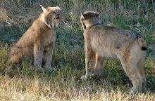
One other plus about living up here is the supply of free meat. It appears that when the big sports hunters come up in the fall to do their big game hunting, all they can take home with them is the trophy head. The outfitting companies cannot sell the meat nor leave it to waste, so everybody puts their name on a list and as the meat is brought in it is divided up among those on the list. Needless to say, most local freezers are filled with moose and bear meat to last the winter, at no charge. A great system!
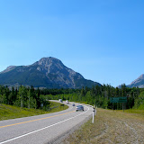
We got up early the next morning and headed out for Mayo. The sun was shining and the drive back down to the Klondike Highway was good. Slow going over the 20km of gravel road, but allowed us to get some good shots of the Yukon River. Stopped in Carmacks to fuel up and paid $1.14/L for 140L of diesel. Prices increase as you go north and we thought that it could even be higher in Mayo. (We were right, the price in Mayo was $1.28/L)
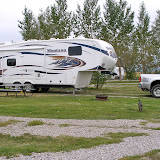
Some parts of the Alaska Highway are being resurfaced and needless to say we ran into a lot of dust from the graveled sections. The weather became cloudy with the odd shower going up to Pelly Crossing, where we turned off and headed towards Mayo. The 60km drive was not overwhelming, to say the least. We arrived in Mayo looking for the two “free” RV parks. Found out that they were free because they were run down with no facilities as well as being too small for out rig. It took some swearing and jigging back and forth to extract us from a tight spot. Thankfully, the young attendant in the tourist bureau in Mayo suggested the Yukon government campground just 5 miles outside town called Five Mile Lake Campground. Unserviced, but all 20 sites were good. Pit toilets were clean and there was firewood and water available although the water needed to be boiled for 10 minutes. We always carry drinking water and onboard water for dishes, so this is not a concern. Only two other sites were occupied by campers. Very quiet campground and very bright as there are only a few hours of complete darkness. At $12.00 a night, this a good deal, so hopefully we can find a few more like this one to help keep the budget in line.
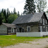
We got up on Monday morning and drove the 60 odd km to Keno City, population 20, sometimes as high as 30. It’s dirt road the whole way, but a good dirt road as they are still mining silver in Elsa. The scenery along the drive from Elsa to Keno is magnificent although the dirt road is in poorer condition. The mining museum in Keno is well worth the trip, even with the $5.00 admission price for two people. Talked to a chap at the museum who has lived in Keno for the past 40 years. He lived in Whitehorse for three years but found it too noisy and it had too many people. He said it only took him 1/2 hour to pack his belongings in a car and get back to Keno. He also said that he expected to see boom days ahead for Keno. I asked him how that would affect him with more people and noise. He said he would just move further back in the mountains where he has a small cabin. He also told us that at the large silver mining operation in Elsa, turnover of staff is 300 % per month. It’s a hard life and not too many young people are up to the challenge.
Another interesting story comes to mind. Should have talked about this one when we were in Whitehorse. One of our propane bottles had to be refilled. I had it chained and locked in the back of the truck, along with our generator until I found a place to fill it. Found a propane station and proceeded to unlock and unchain the bottle. The old chap, waiting to fill me up made the following comment. “Don’t need to do that here sir. Everybody here knows that there is a rifle in the truck.” Apparently “everybody” carries their rifle in their truck up here. An important thing to remember!
Back to Keno City. This place is well worth the visit. Unfortinately we cannot say the same about Mayo. Enough said!
Tomorrow morning we leave for Dawson City and plan to spend a few days there. The Dempster Highway is apparently still flooded out so out trip to Inuvik looks less likely now.


Quote for the day:  Doing nothing is very hard to do...I never know when I'm finished.

I wasn’t going to do anything today; so far, I’m right on schedule.

Cheers

P & N

Saturday, July 24, 2010

North in the Yukon

After spending two days in Whitehorse getting restocked, we left and headed up the Klondike Highway to Carmacks. At Carmacks we turned right and headed up the Campbell highway (Rt#4) to the small town of Faro. Faro calls itself the Yukon’s best kept secret and we just had to go in to find out what the secret was.
The drive into Faro, some 170km long is just amazing. The first 50 to 60 km consists of fairly long climbs with spectacular views of the Yukon River winding down a large valley.  It was along this stretch that we had 20km of gravel road to contend with. It was smooth but the gravel was loose and somewhat similar to driving on ice. Needless to say N was a bit stressed out. She does not like the feel of our 11 tons moving around on gravel.
The next wonderful sight was Little Salmon Lake. How it got its name I’ll never know. It’s about 30km long and is deep. On the far side (south) of the lake everything is black due to a massive forest fire last year.
Arrived in Faro and our first stop was at a beautiful reception center to register for our campsite. The town has a RV park with 12 sites and most have electricity, sewer and water. They are $12.50 a night taxes included. There were hot showers and a fully equipped laundry room. Our first quick walk around town showed that the attraction to Faro was the wilderness around it. The town itself now supports a population of some 340 people, a far cry from its population of the 80s and 90s when it operated one of the largest open pit mines in the world. Needles to say, the town is like many other boom and bust mining towns. Mainly empty buildings and company houses boarded up and falling down. There is a large new looking recreation center and town hall. There is very little if any commercial activity except for a number of artists, hunting and fishing outfitters as well as some small scale mining operations in the area. The service station has burnt down and I’m not sure if there is another one to replace it, there are no motels or hotels and only one very small hardware/grocery store. I saw one B & B but it was closed.
The people we met are friendly and obviously enjoy their life in relative isolation. Any major shopping is at least 170km away.
The real beauty of the place is the wilderness, wildlife and the quiet. It is located in the Tintina Trench, a huge valley that runs for hundreds of km north to south. It provides one of the major wildlife migration corridors every fall and spring.
One very interesting feature of the town is its golf course. The nine holes run right through town, over streets, around buildings etc. Today there is a series of arts and crafts workshops and a “wild meat bar-b-q.
Tomorrow we leave for Mayo. One quick update. Just heard that the Dempster highway is closed due to heavy rains and washouts. I hope they get it repaired before we get there.

Quote for the day:

Consistency requires you to be as ignorant today as you were a year ago.
  - Bernard Berenson

Cheers

P & N


Wednesday, July 21, 2010

Heading North Part 2

Had a good night's sleep in spite of having only 5 hours darkness.
Back to my story about N and her fishing adventures. The next morning we walked up a trail along the lake to the gravel bar near the mouth of the river. The first thing we saw was a large bald eagle as she lifted off from her nest scolding us for disturbing her morning. The next thing we saw were eleven, yes eleven loons patrolling the waters off the bar diving and fishing for breakfast. Never saw so many loons together in my life.
We didn't dare start casting for fear that a loon might decide that the lure was edible and gobble it down. It was frustrating, because the fish were jumping as the loons were diving and we couldn't cast out to where they were.
Finally the loons moved off and we could start fishing. The sun was out and things were starting to warm up from the 0C night temperature we had just had. Fished for two hours and never got a single bite. On the way back to the campsite we noticed a path down through the trees to a nice little beach in a small cove and decided that we would come back in the evening and fish from there. I didn't bother to mention to N that there was a pile of bear scat beside the trail as she has this thing about big bears. They scare the he-- out of her!
After we had dinner we walked back to this new spot and started fishing. The fish were breaking and jumping and we really should have been fly fishing. N started casting out with a red devil lure and on here second or third cast got a strike and hooked one. Her first catch. She was holding on for dear life pleading with me to tell her what to do next. Now, this was a first for me. N had never asked me what she should do so I was enjoying the situation as much as she was. She finally landed her first rainbow trout. A small one, a little over 12 inches long, but a nice one. She was grinning from ear to ear and I knew that a new fisherman had just been born! It's not a two headed fish but rather hers and mine.
In the next 20 minutes I was able to land two more that were bigger than hers, thank heavens, and we decided to call it a day. When we got back I cleaned the fish and reminded that her next lesson was going to be fish cleaning. I'm a firm believer that if you catch them, you clean them! Tomorrow night's dinner was in the refrigerator.
I have now been informed that when we get to Whitehorse that we have to buy her a rod and reel so she doesn't have to use mine. I'm also faced with double the costs of a fishing license, one for me and one for her. The cost of living on the road has just gone up again! Look out for a decrease in the Yukon fish population. There is a new threat out there.
We left the next morning and headed towards the next fuel, and food stop at Dease Lake. It was slow going as there were several delays for road construction and a lot of dust. Finally arrived and stopped at the ultimate one stop shopping outlet. Diesel fuel, gas, groceries and a liquor store that stocked black rum. The rum was a key find as I was down to less than a 1/4 bottle from my stock purchased in N.S. N assured me that fuel and food had a higher priority, so we fueled up, bought groceries and then I bought the rum.
We arrived at another of our favorite Provincial Parks, Boya Lake, by mid afternoon. The color of the waters in this lake is beautiful. N's enthusiasm for fishing waned a bit when the ranger advised us that there were bears in the area. We had another good site, right on the water, so we sat back and enjoyed the late afternoon peace and quiet.
The next morning, July 20, drove the remaining 90 km of the Cassiar hwy. N, ever alert for bears finally got pictures of a small one about 10 km from Boya Lake. The rest of the drive to the Junction of the Alaskan Highway was uneventful as was the drive up to Caribou RV Park, in Whitehorse, where we are going to spend the  next three days re-stocking our supplies, picking up a new fishing rod for N. and get a rough idea of how we will spend the next month up here. We want to get to Faro, Ross River, Mayo, Keno City. Dawson City, Dempster Highway, Inuvik, Kluane National Park and the Top Of The World Highway to name a few. Internet and cell phone service is available in major centers, according to the brochures so we will post whenever we can from where ever we are.
Spent the morning in Whitehorse picking up a few things. Found a great little local meat market and deli. They carry bison, reindeer, caribou meat along with wild salmon etc. Also found out that next weekend in Faro they are having a wild meat bar-b-q. Sounds like fun! Got to run and hide as N has started house cleaning.
Addendum for the Quesnel post. I was playing darts with N and she said she was not going to leave until she hit the bulls eye. I suggested that being the case we would be there all night. The next dart she threw resulted in this. I was forced to add this to this post!

Quote for the day:  You can only be young once. But you can always be immature.
  - Dave Barry

P & N

Heading North

This will be a post covering several days. It is being written off line because I’m not sure where my next internet connection will be over the next few days. We are heading into that area of the country that makes people, who are used to modern electronic communication systems, go into severe withdrawal status. No cell and no internet service! I think there is a pay phone at the campsite we are at tonight.
But first lets go back to Tuesday, July 13th. Got up in the morning and decided once again that the weather was too iffy to do the “back route” from Barkerville to Likely. We packed up, said goodbye to Quesnel and headed north towards Prince George. With the exception of some small delays for road construction, we passed through Prince George and continued on to a small community on the Yellowhead Highway called Vanderhoof. Stayed at Dave’s RV Park which was a number one place to stay. Clean and comfortable.
Got in early enough that we took a 60 km side trip to a National Historic Site, Fort St. James.
This was a Hudson Bay Post of the 1800’s that has been reconstructed. Very interesting site. Gives a good history lesson on the local 1st nation clan called the Carriers. They are a sub-clan of the Dene Nation. The warehouse and trading post themselves were well equipped with trade goods of the day as well as an ample supply of furs which was the cash of the day. The furs collected here by the Hudson’s Bay Company were shipped by mule pack trains, boat and barge to Prince Rupert on the Pacific coast. From there they were loaded on ships which sailed down around South America and up to Montreal where the HBC headquarters was located. From there they were graded and loaded on ships for England. The length of this trip for the furs took one year.
The site had about four animators playing various roles depicting what life was like back then. From what I saw I would suspect that there were many more people working there as animators and demonstrators prior to the budget cuts that the Parks Service has faced over the last few years.  One interesting thing they are trying here this year is providing a Bed & Breakfast, for a fee, at the home of the senior HBC man at the fort. They say it’s being well received and quite successful.
Got back to the campground, had a late dinner and got ready to leave for Kitwanga and the start of the Cassiar Highway to the Yukon.

We left for Kitwanga early in the morning. It was an unevenful drive. Weather was cloudy with a few showers. Lots of fishermen along the Skeena river as the “pinks” were running. We arrived at the Cassiar rv park in Kitwanga by late afternoon. The place has changed and generally looks run down. The owner is sick and friends are trying to help but it is obvious that maintenance is suffering.

Got under way early the next morning and drove up as far as Meziadin Provincial park. Got a nice lakefront site. Improvements made to the park since three years ago have it looking better than ever. Wind was blowing hard but not hard enough to stop the sockeye salmon from jumping. The park warden told us that 5000 sockeye were coming through the counting site daily. I bought a non resident fishing license from him, which allowed me to fish all inland waters in BC. The sockeye weren’t biting.

Driving the Cassiar is not the adventure it once was. Almost all of the 700+ km are paved or chip sealed.  The interesting thing is that they did not do much, if anything to widen the highway so now you have a narrow paved road with absolutely no shoulder.  This means if you drop a wheel off the pavement, you go in the ditch or down an embankment that could be as deep as 100 feet. We saw a one ton truck about 50 down in one spot and a semi that did the big dive in a ditch. Don’t know if the driver got out alive. The rig was completely on its roof and looked quite banged up. It was loaded with salmon which was all gone by the time we got there.

We left Meziadin and drove to the next park about 250 km up the line. Kinaskan is our favorite place.  It is a huge lake with lots of rainbow trout. We just arrived and got set up when Bob and Barbara (our camping neighbors) came over to see us. Bob had a boat and  asked me to come along. We got two nice rainbow for dinner that night.

The next day, I thought that it might be a good idea to teach N how to spin cast for trout. I set her up with a old rod I had, some lead weights on the line. I showed her the basics and left her to practice while I went to fish. By the end of the day, I had no fish and she could cast the lures out further than I could. I could see trouble on the horizion!  Getting late tonight so I’m going to quit writing. I’ll carry on with this story tomorrow.

Monday, July 12, 2010

Monday in Quesnel

I decided that I wanted to get the truck checked out. Nothing specific, but didn't seem to be running right. Arrived at Cariboo Ford at 7:30 AM to see what the chances were of getting the truck looked at. Met a first class service advisor Patricia Reistad who was able to juggle a busy booking day to get me in for service in the afternoon.
Spent the morning sort of housecleaning the trailer, topping up the grocery larder. After lunch went down to the local museum. Quite large and well displayed. The museum here in Quesnel is one of the top ten museums in the province. The only problem I have with museums in the west, is what they call old and fit for a museum is the stuff I grew up with and remember. At least back east the stuff there is a couple of hundred years older than I am. Guess I'll stop going to these museums out here!
Had the truck checked over. All is ok as they could find nothing wrong. Must have been my imagination or I'm starting to suffer from rum withdrawal.
Over all, a good day. Gave us a bit of a break to catch up on a few things. Now the weather forecast for tomorrow is light rain. Will make the decision later on tonight, but might chance the "back road" tomorrow. Understand it is passible with caution.

cheers

P & N

Cottonwood House & Wells

Well, we did not get to travel the 100+KM of the Back Road today ( Sunday) as planned. Weather forecast was calling for severe T-storm warnings. And I thought we left those behind on the prairies!
Rather than take the chance of being caught in a potential mud-slide or caught in high water run off, we decided to cancel the back road trip.
Instead we headed back towards Barkerville to check out some other historic sites. Our first stop was at Cottonwood House which is a preserved roadhouse east of Quesnel.  Very interesting place! Has cabins for rent as well as one miners cabin without modern conveniences. The general store had a great little restaurant with reasonably priced food. Photos of Cottonwood are being posted on a Picasa gallery which you will find on the left hand side of this screen. I'll be posting photos this way from now on. Got the suggestion from a MOC (Montana Owners Club) member, Mrs. Country Guy. Twenty some odd pics there now and more later.
From Cottonwood house we moved on to the ghost town of Stanley. All that remains is the cemetery and one old building that was a hotel. Interesting graveyard. Surrounded by white picket fences and mostly wooden markers. There are several places where the graves have been dug up leaving indentations in the ground. This is where members of the Chinese community in Stanley were buried. Later the Tong society had the bones dug up and sent back to China so they could be interned with their ancestors.
Carried on to Wells. Not overly impressed. Had been told by a local that the old hippies had taken over the town. I think they were right. A few good artists, lots of junky properties for sale.  A few of the houses were brightly painted. I think there must have been a sale on shiny aluminum roofing panels, as every second house had a new roof. Stopped at the museum and after a donation spent all of 20 minutes looking at the material on display in great detail. That was it!
Headed back to Quesnel and called it a day around 4 PM.
N. played hide and seek with a small moose trying to get a clear picture without much success. If you look real close you will see him staring at her.

Quote for the day:

The one serious conviction that a man should have is that nothing is to be taken too seriously.
  - Nicholas Butler

Cheers

P & N

Sunday, July 11, 2010

Quesnell and Barkerville

Left Cache Creek early Friday morning while it was still relatively cool 20C. We were not impressed with the first 100KM of the Cariboo Highway. Land is very poor, buildings and homes in very poor state of repair. It was probably one of the poorest areas of Canada that we have driven through. We only took a couple of pictures due to the shape the buildings were in as well the amount of junk cars, farm and industrial machinery that were rusting away in the yards.
The land had some interesting shapes and soil colors. We were slowly moving out of the desert environment into an area with more trees and green fields. There was quite a lot of highway construction on this stretch of highway as the BC government is turning this highway into 4 lanes from 2. Once we got to Williams Lake the countryside looked better and N began to get more active with the camera. We'll add those pictures to the pictures page later as photos are downloading very slow tonight. Must be a lot of people in the campground using the internet.
Arrived in Quesnel (pronounced kw-NELL) around lunchtime. Things got a bit interesting in the last kilometer before out GPS was to lead us into this campground. The navigator was following the GPS closely, when Jill (our GPS female voice) told me to turn right, which I did. Very quickly learned that we were entering the loading yard of a VERY large sawmill operation. Nothing to do but say a few blessings and follow her along. She eventually led us back to the highway but we were so shook up that we stopped and called the campground to find out how to get there. Come to find out we were only 500M away, so in 30 seconds we were in the yard.
Quesnel is an interesting small city. It's basically a lumber economy driven town. Two pulp mill, five sawmills, one plywood plant, planer mills and an MDF plant. As well it plants hundred of thousands of flowers along the city streets, and has won many awards over the past few years for these efforts. We spent some time down town to replenish our groceries and look around.  The city has walking trails and parks all along the river. As well, they have restored an old bridge to a walking bridge so we are probably the only people from Bridgewater who can claim to have walked across the Fraser. The water was high and moves along at a fast clip even this far away from the ocean. 
The other thing we noticed was a visible police presence in the down town area.
On Saturday we headed in towards the Cariboo Mountains to the restored gold mining town Barkerville.
The internet is speeding up so I think I'll continue and describe our trip to Barkerville.
It's about an 85KM drive, mostly uphill. On the way in you pass several ghost towns, mostly off little side roads that have nothing left but overgrown cemeteries and maybe some foundations. Also passed the site where a murder was committed and the only white man to be hung in Barkerville was the guilty person. Apparently he paid for the services of a prostitute with the diamond stick pin of the deceased man. 
Barkerville was founded by Bill Barker who struck it rich in the area. At one time Barkerville had a population of over 10 thousand people. One half of that population was Chinese who worked for low wages in the mines. They also started up businesses in town - laundry, bathhouses, restaurants etc. The south end of town was the "Chinatown" section. 
We took over 100 photos in Barkerville and most of them will be posted on the photo page.There are 130 buildings that have been restored to varying degrees. It is a job of love by a lot of private individuals who raise funds and obtain a few grants from the provincial government. They do a great job. There are several restaurants, bed and breakfasts and it is open year around. There is of course an entry fee, but well worth it. The town had one full time resident. The postmistress, who also runs one of the bed and breakfast operations. It takes a good full day to take in all the sights and interact with the people who role play in town. We met the town doctor, the postmistress and a beautiful lady of doubtful character as she worked in the local theatre. I just had to have my picture taken with her.
We ate lunch at the local chinese restaurant called Lung Duck Tong. We ordered combination plates and the food was just super. The price was reasonable as well. I had chinese tea while N just had water. Watched several demonstrations relating to mining. Boy, it was a hard life. Miners lived to the average age of 35 years old before they died, either through hard work or accident. As well broken limbs, mangled hands put an end to many dreams of getting rich.
The interesting thing is that most miners who struck it rich died paupers. You have to be a gambler to chase gold and I guess they gambled with the money they made. The ones who got rich were usually the merchants. I'll close off for today with the picture of the lovely dancehall lady. 
Tomorrow we head back towards Barkerville to another gold mining town called Wells. From there we plan to take a back country road up into the Cariboo Mountains. It's about 130KM long and is all dirt. It's supposed to be a great place to spot wildlife and there are lots of bears in the area. We hope to get a lot of good pictures. The road is supposed to be passable. We have been assured that the big 4 wheel drive should be able to get through.
Thats all for tonight!


Quote of the day:

You don’t stop playing because you grow old. You grow old because you stop playing.

Cheers

P & N


Thursday, July 8, 2010

Hotter

Things are warming up. We are in Cache Creek, just west of Kamloops. This is sand and sagebrush country. Aside from the blue skies and the occasional irrigated field everything else is varying shades of brown. High is 33C+.
Just got back from a nice long dip in the pool and we are washing the chlorine taste from our mouths with Gin and tonic. The gin is necessary to kill any residual bacteria that the chlorine did not get.
Had a small bit of excitement last night in Valemount. We went for a walk to get some photos of a plant called horsetail. Heard a big snort as a moose took off down the trail just ahead of us. The only part of he, she or it that we saw were the fresh tracks it left as it ran away.
Today's drive was good. Sunny & warm, minimal traffic and lots of great scenery. Drove past the only visible glacier on Route 5 south. It is located about 20 miles south of Valemount and neither one of us can remember the name of it. Arrived in Cache Creek in time to do some grocery shopping at the local "grocery mart". Limited volume but had one of just about anything.
Leaving tomorrow am to travel up Route 97 towards Prince George. Plan to spend a few days in the Barkerville area just being tourists.
Will keep you posted whenever internet is available.

Quote of the day:


Slow down and enjoy life. Its not only the scenery you miss by going too fast - you also miss the sense of where you are going and why.

Cheers

P & N

Sunny and Hot

Finally, summer weather. High of 30C in Valemount our second day here. Cool in the evenings but great for sleeping. Started our day off with a 2 hour walk at a local wildlife park called Starratt Marsh. Nice trails, two viewing towers but a scarcity of waterfowl. We only saw a male Ruddy Duck and a couple of female American Coots with young ones following behind them. Lots of marsh but also a lot of large trembling aspens, cotton wood trees and spruce. Found out last night that aspens grow from root systems and not seeds. Some of the root systems are thousands of years old. So, when you see a group of aspens growing in one spot, it is called a colony because they all grow from the same root base
After lunch we spent some time at the local museum which gave us a good insight into local history as well as many of the characters that lived in this area. It is located in an old railway station that has been restored.
I don't know how such a small community (Village) can afford all the work that has gone into a downtown street and sidewalk renovation, a huge information bureau and interpretative center, a first class museum with 80% of the buildings  downtown that are empty stores that no longer in business. Sounds like Lunenburg!
We are off tomorrow morning to Cache Creek and then start our way up the Cariboo highway to Prince George with a multitude of stops in between. I hope that some of the places we will stay at have internet service so I can keep this blog going.
Take note of a new page added to this blog. You will find it on the left hand side of your screen under Pages with a title of Photos.
This page includes nothing but photos with a short note on each one. These are photos that are not in the blog.
Getting late so have to go. Back soon!

Quote of the day:

Experience is a hard teacher because she gives the test first, the lesson afterwards.  Vernon Sanders Law
Cheers

P & N

Wednesday, July 7, 2010

Out of the Swamp

We finally left Saskatoon on Sunday morning. Saskatoon did not let go of us easy  either. On Saturday night the weather radio started its warnings and we got more T-storms and heavy rain.
However, the sun was shining and not a cloud in the sky on Sunday! We detoured off the Yellowhead Highway to take a secondary route to Alberta. Route 14 across Saskatchewan and then Route 13 in Alberta. Beautiful day. Sunny, light winds and then late in the afternoon just as we were checking into our campground south of Edmonton a couple of thunderstorms popped up and gave us a bit of rain.
Woke up in the morning with cloudy skies, 8C and rain. We left for Edson following Route 13 to Route 22, the "cowboy trail, and then back to the Yellowhead. There were several Elk, buffalo and horse ranches. High for the day was 11C. Met our friends in Edson and spent just enough time to catch up on a couple of years before they left for Stony Plains and parents 50th wedding anniversary.
The RV park we were in was full of "workers". Pipeline workers, forestry workers, truck drivers etc. I think we were the only tourists .
Left early this morning heading for Hinton and Jasper. Good driving. Light traffic and sunny skies. We were heading to a campground in Valemount BC and got there around noon in 28C weather. Starting to see some wildlife. N  barely got a picture of a wolf running past us and did get some photos of a big horn sheep holding up traffic in Jasper.
Mount Robson was in grand form. Clear at the top and warm weather below.
We have decided to stay here for two days. The place is beautiful with mountains on all four sides. Going to do some local sightseeing tomorrow including a museum, bird watching, and mountain horseback riding. Will have to find someway to tie N into the saddle so she doesn't fall off and break some of her fragile bones.
Hopefully will be able to post the results of tomorrow's adventures tomorrow night.
This evening we went on a local interpretive tour looking at local plants, their uses and cures. Did you know that common Yarrow is excellent to use to stop bleeding from a wound. Rub your hands on the bark of the trembling aspen and the white powder that comes off the bark is excellent sun screen. Something new every day.

Quote for the day:

Experience is the name everyone gives to their mistakes     Oscar Wilde

Until the next time
Cheers

P & N

Saturday, July 3, 2010

Closer to the mountains tomorrow

A sequel to the last post about the storms in Saskatoon. We heard on the news that the city received 84mm of rain in just three hours. It was the second highest rainfall ever recorded for the city. Flooding has been wide spread and the city is appealing to the Provincial Government for disaster assistance. More rain is due in the next couple of days. We might have to put floats on the rig to get it out of here on Sunday.
On Canada Day, Yorkton received 100mm of rain in less than 2 hours. Flooding is bad and traffic is being re-routed around the town. I’m writing this on Friday evening (hope to post tomorrow) with severe T-Storm watches on the weather radio. Thunder and lightning all around us and raining hard. On top of the rain we had the other day, this place could be a lake by tomorrow morning.
Now, to nicer things.
Spent the last two days being tourists. Drove around Saskatoon and got to know the city quite well. This place is very clean and neat. Found a major shopping mall for groceries and a couple of other things we needed. We were impressed with the staff in all stores we visited. They were polite and in most cases went out of their way to help us find what we were looking for.
We spent an interesting 1/2 day at the Wanuskewin Heritage Park. It is located about 5KM north of the city. It is a beautiful location that gives a history of the plains Indians, their lifestyle and history. The center has both static and animated displays. We were able to watch the prairie chicken dance conducted by a native Navaho (Dene) originally from Arizona. He was in full regalia and accompanied by a local drummer singer.
I had an interesting discussion with him after the performance. I had always associated the Dene clans as being northern prairie, North West Territory natives. The Navaho are a branch of the Dene Nation that moved south to Arizona centuries ago. The Dene originally came from northern Asia and crossed the ice bridge that joined North America and Asia a few thousand years ago.
Unfortunately, the heavy rains had washed out all of the interpretive trails that included small tee-pee villages, historic excavations and a lot of information on the natural environment that sustained the early natives.
There was a nice little restaurant that served a multitude of interesting items. Buffalo stew, burgers, along with bannock were some of the more interesting items. N and I opted for a bannock pizza with shaved buffalo meat, cheese and spicy tomato salsa. This 10” pizza came with a salad and fries, which I don’t think was part of the original aboriginal diets. The pizza was absolutely delicious. The crust was light and filling and had a taste all its own. Delicious!!
We are heading west on Sunday morning. We hope to meet some old friends someplace between Edmonton and Jasper on Monday or Tuesday. Then into BC and towards Kamloops.